Map by mapchart.net - Some rights reserved.
Location
near Kilpeck, Herefordshire, England
Description
Kilpeck Castle is located about eight miles south west of Hereford.. The earthworks consist of a motte with a base diameter of about 50m at the base and about 8m at the top. The motte is surrounded by a ditch. The inner bailey has remains of a wall along the north and south sides. There are fragments of wall from the 12th century or 13th century keep on the motte summit. The keep is thought to have been polygonal in shape. A deep well has also been discovered within the keep. The remains of chimney flues are also visible within the wall fragments. The ruins are in very poor condition.
History
Kilpeck Castle is thought to have been built first around 1090. King John stayed in the castle in 1211,1212 and 1214. The castle was abandoned in the late 14th Century and it was falling into ruin by the 16th century. During the Civil War it was garrisoned between 1635-1645. The Parliamentarians destroyed it at the end of the war.
Other Castles in the Area
Goodrich Castle, Herefordshire
Longtown Castle, Herefordshire
Abergavenny Castle, Monmouthshire
Crickhowell Castle, Powys
Grosmont Castle, Monmouthshire
Hay Castle, Powys
Raglan Castle, Monmouthshire
Skenfrith Castle, Monmouthshire
Tretower Castle, Powys
White Castle, Monmouthshire
|
|
|
|
|
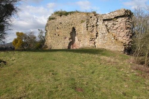
Little remains of Kilpeck Castle. It is situated just to the west of the church, part of the castle grounds are now used for burials.
Photograph by Philip Halling. Some rights reserved. (view image details)
|
|
© OpenStreetMap contributors licensed as CC BY-SA
|
|
|